ABE 1995 Survey Results
Near-Bottom Magnetic Surveys of the Coaxial Ridge Segment Juan de Fuca Ridge Using the Autonomous Benthic Explorer Survey Vehicle
M A Tivey (Dept of Geology and Geophysics, WHOI, Woods Hole, MA 02543) D Yoerger ,A Bradley, R Bachmayer, R Catanach, A. Duester, S. Liberatore, H Singh, B Walden (Dept. of Applied Ocean Physics & Engineering, WHOI, Woods Hole, MA 02543)
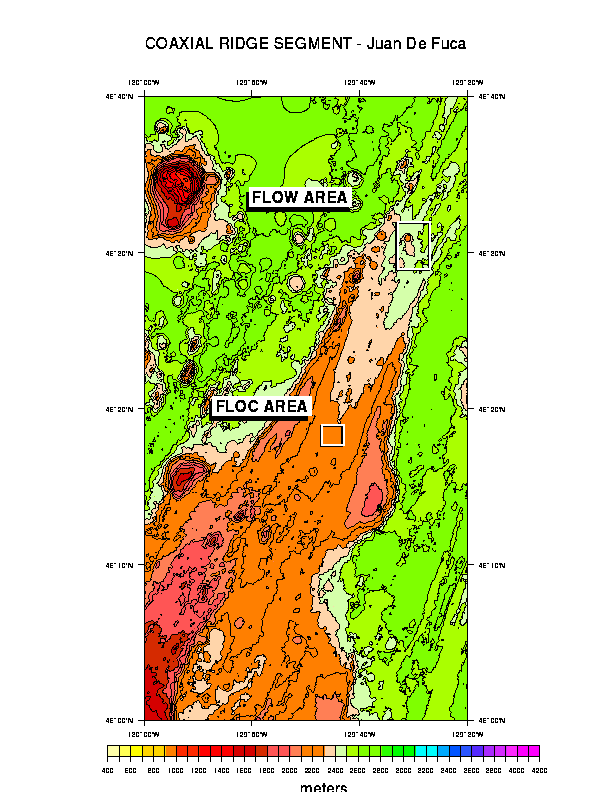
The autonomous survey vehicle ABE (Autonomous Benthic Explorer) was successfully used for the first time in a series of near-bottom magnetic profiles over the 1993 eruptive lava flow area of the Coaxial Ridge segment of the central Juan de Fuca Ridge. Over 20 km of tracklines were obtained using ABE over both the Flow Site which includes the 1993 lava flow and associated graben and which is thought to mark the location of the dike that fed the lava flow and over the Floc Site, 25 km south of Flow along-ridge strike, where a narrow, lineated graben contains a zone of continued hydrothermal activity that was initiated during the Coaxial eruption event.
The ABE vehicle carried out untethered operations at an altitude of 5 to 100 m above the seafloor obtaining vector magnetic field, depth, altitude, and water column data. Several profiles also collected digital on-bottom stereo video still images of the new flow. ABE conducted its surveys using both surface and in-hull long baseline acoustic navigation, allowing it to vector to a specific starting point on the seafloor. Using an acoustic altimeter, ABE was able to maintain bottom contact and safely clear obstacles in its path. A solid-state low-power gyro enabled ABE to maintain heading despite magnetic anomalies exceeding 20,000 nT associated with the new lava flow.
Preliminary magnetic results find that a narrow notch-like anomaly low found in 1993 magnetic surveys over the new lava persist in the 1995 surveys. This suggests that the notch anomaly locates the presence of a now cooled dike intrusion zone that fed the Coaxial lava flow eruption. Magnetic field measurements linked with the rapid survey and response capability of ABE thus provide a unique opportunity to map the subsurface and time critical events such as seafloor eruptions and hydrothermal activity. The ABE platform also provides an efficient use of survey time allowing a multitude of sensor measurements to be obtained over a tightly constrained survey near the seafloor without the need for large winch and ship operations.
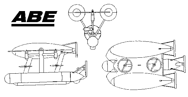
Autonomous Benthic Explorer
The Autonomous Benthic Explorer (ABE) was designed to address the need for long-term monitoring of the seafloor. While manned submersibles and ROVs allow intensive study of an area, they can remain on station for only hours, days or weeks. Consequently, a system that can remain in an area gathering data to fill the time voids between submersible and ROV visits would provide another level of more detailed information on temporal variations. Cameras and other fixed instruments may not always be the best solution to this problem because they have limited spatial coverage and are vulnerable to fouling from bacterial growth or mineral deposits.
After discussions with many scientists studying hydrothermal systems, the concept of a roving robot that could remain working on station for up to a year was developed. The robot would spend most of its time "sleeping" in a safe location, then, at pre-programmed intervals, undock, perform a survey with video cameras and other sensors, then redock and go back to "sleep". From these ideas, the Autonomous Benthic Explorer was created and built at Woods Hole.
To minimize cost, ABE is a three body, open frame vehicle. This allows glass balls to be used for flotation (there are three in each of the two free-flooded, upper pods), and all the batteries and electronics to be placed in a single, lower housing. This separation of buoyancy and payload gives a large righting moment which simplifies control and allows the propellers to be located inside the protected space between the three, faired bodies. ABE has seven thrusters and can move in any direction. It can travel forward at 1m/sec on about 50 watts to its motors. Navigation and control take only about 12 additional watts. As configured in 1995, ABE's principal data is monochrome and color video stills of the bottom at selected locations; however, ABE can carry other sensors as required (e.g. CTD and magnetometer). The image recording system has been designed and built by a team led by M. Namoto at Japan's JAMSTEC research center, which is doing research with autonomous vehicles. This team expressed interest in collaborating in this project early in ABE's design cycle, and they have already delivered the prototype imaging system. They are now working on techniques for recharging ABE at its docking station between surveys.
The imaging system supports three CCD cameras in separate housings. These may be aimed in different directions for different missions. Two of the cameras are black and white and one is color. Each provides an image resolution of 512 x 512 pixels with a dynamic range of 8 bits. The images are recorded on two 512 Mbyte hard disks which can accept images from all three cameras as fast as once every 2 seconds. The disks can store 3900 image planes. (One color image has three planes while each black and white has only one). The cameras can capture images simultaneously from a single flash to provide stereo imaging. Data from other sensor systems can also be stored on these disks, which will ensure that it will be properly synchronized with the imagery.
Currently ABE is powered by rechargeable gelled lead-acid batteries to facilitate testing and keep the cost down. Even with these batteries, ABE could travel over 50 km in a straight line. In any real mission, however, the energy required to maneuver, operate the sensors, and power the flash will limit the range to a fraction of this value. For a long mission, alkaline batteries could be used for an improvement of over four in energy available. Ultimately, lithium batteries will be installed for an improvement of more than twelve in energy compared to the present lead-acid cells.In order to accomplish its scientific objectives, and ensure vehicle safety, ABE must have reliable and precise navigation and control. Two complementary navigation systems that are already proven in previous deep-ocean operations have been selected. Medium frequency (10-14 kHz) transponders, identical to those used for ALVIN, guide ABE during descent to its worksite, and are used to navigate for surveys over long distances. With this navigation system, ABE has the ability to follow tracklines with repeatability of several meters.
At the worksite, ABE switches to broadband 300 kHz transponders to navigate precisely over ranges of about 100 meters with a repeatability of several centimeters. This system (EXACT) has been demonstrated on the ROV Jason at Endeavour and Guaymas Basin vent sites. With two navigation hosts on the vehicle and two transponders, ABE can obtain a range and bearing from either transponder, or it can obtain a long baseline fix when ranges to both transponders are available. In our on-going dockside tests, we have demonstrated that ABE can hover and follow tracklines within several tens of centimeters, and most importantly, it can return to its docking mooring. In addition, ABE's power consumption during closed-loop maneuvers falls well within previous estimates.
In the spring of 1993, as soon as it was mechanically complete but before the navigation system was installed, ABE was taken out on the ATLANTIS II during a series of ALVIN engineering dives. An anchor was rigged on 60 m of line below ABE and the combination was allowed to free-fall to the seafloor at a depth of 1600 m. After reaching the bottom, ABE exercised its seven thrusters one at a time, recording the rpm resulting from the varying torque commands. This tested the control system, internal communication bus, power system and all the thrusters. At the end of the test, ABE released its anchor and freely ascended to the surface. Its progress was followed by measuring range to one of its two built-in transponders and it was quickly located on the surface.
Since then, we have been steadily building up ABE's capabilities and teaching it to do increasingly involved tasks. In the summer of 1993 it was performing brief autonomous missions using dead reckoning navigation. The video system and the EXACT navigation system were added in the fall of 1993. The navigation system is performing well, and allows ABE to hover (holding x,y,z and heading) in strong tidal currents with only a few centimeters of wander. Forward or sideways movements can be commanded and ABE executes them smoothly. In addition, ABE can find the beacon marking its docking mooring, turn toward it, and dock.
In June 1994, ABE was shipped to join the ATLANTIS II in San Diego, again in conjunction with a series of ALVIN engineering dives. ABE's capabilities to conduct repeated dockings, follow tracklines within the ALVIN transponder net, and capture images at specified locations were demonstrated.
The first real science mission occured in mid-1995, when ABE was used to conduct a complete magnetometer survey over a lava flow, known to have erupted in July 1993 along the CoAxial Segment of the Juan de Fuca Ridge. A previous survey conducted from the ALVIN indicated the presence of a notch-like magnetic low at the center of the new flow, which has been interpreted to be related to the thermal demagnetization of the underlying feeder dike. The survey with ABE, which flew at an altitude of 20m above the bottom and covered an area of one km by 300m with about 20m spacing between tracklines, was designed to investigate how this anomaly changes with time, thereby providing constraints on the cooling and structure of the lava flow.
Any investigator who might be interested in using this vehicle for research should contact Dr. Albert Bradley at (508) 289-2448, fax (508) 457-2195, or email: abradley@whoi.edu.
FLOC AREA - ABE MAGNETIC SURVEY
The FLOC Area located at 46°19'N 129°42.5'W was the site of significant hydrothermal venting activity during the Coaxial 1993 eruption event and hydrothermal activity continues at the HDV vent site (ABE-15 on Figure 2C). The hydrothermal activity is located along a narrow graben feature that marks the trace of the Coaxial ridge segment neovolcanic axis which can be traced northwards 40 km to the new lava flow eruption site (FLOW Site). Repeat SeaBeam bathymetric mapping over the FLOC Area has determined that depth anomalies exist less than 1 km to the west of the graben indicating the possible presence of young lava flows (ca. 10 years old). Recent ALVIN dives have confirmed that these are young lava flows. The graben is thought to represent the surface expression of a subsurface dike that, further north at the FLOW Site, broke the surface and formed the new lava flow. The 1995 magnetic surveys with ALVIN and ABE set out to map the possible magnetic effect of a still cooling subsurface dike one.
The main objective of the 1995 ABE survey over the FLOC Area was to provide the regional magnetic field for more high resolution on-bottom ALVIN surveys. The ABE survey consisted of two ABE dives carried out on consecutive nights, that cover approximately 14 km of trackline. The surveys were conducted at a constant depth (km) except where ABE needed to rise up over bathymetric highs (Figure 2A). ABE navigated to the starting position of the survey using the ALVIN transponder net and then used time, course and heading to carry out the prescribed survey.
Magnetic field data were collected along track by a 3-axis fluxgate magnetometer mounted in the nose of ABE (Figure 2B). The magnetic field data were upward continued to a level plane and then gridded (Figure 2D). The magnetic field data were inverted for crustal magnetization using the Parker & Huestis Fourier inversion scheme assuming a constant thickness source layer 500 m thick The magnetic inversion map (Figure 2E). shows the presence of strong magnetization where the 10 year old lavas are thought to reside. A weak zone of low magnetization appears over the graben but the resolution is poor. Nevertheless the ABE magnetic data provides an invaluable regional database for the on-bottom ALVIN surveys.


FLOW AREA - ABE MAGNETIC SURVEY
The FLOW Area located at 46°31.5'N 129°35'W was the site of the surface lava eruption during the 1993 Coaxial eruption event. Repeat SeaBeam mapping shows that the new lava flow is up to 30 m thick and caps a small ridge that dissipates to the south into a narrow graben. This narrow graben can be traced discontinuously 40 km south to the FLOC Area. The graben is thought to mark the location of the subsurface dike that fed the new lava flow. Hydrothermal activity on the new lava flow as a result of the eruption has now ceased. Repeat Seabeam mapping has also found an older 10 yr old lava flow to the east of the new flow which has been confirmed by recent ALVIN dives.
The motivation behind the magnetic field measurements were not only to determine the magnetic propoerties of a "zero-age" lava flow for subsequent temporal measurements but also to investigate if magnetic fields could detect both recent lava flows and the subsurface dike zones that feed such flows. The subsurface dike zone would be expected to be relatively non-magnetic due to low remanence or thermal demagnetization. The new lava was expected to be highly magnetic as it had not been subjected to long term seafloor weathering. ALVIN magnetic surveys in 1993 over the new lava flow found extremely strong magnetic fields associated with the new lava flow. The magnetic field also showed a distinct narrow magnetic anomaly low notch in the center of the magnetic high. The inference was that this notch may represent the effect of the subsurface dike zone.
The 1995 magnetic surveys with ALVIN and ABE set out to map the possible magnetic effect of a still cooling subsurface dike zone beneath the highy magnetic lava flow. The main objective of the 1995 ABE survey over the FLOW Area was to provide the regional magnetic field for more high resolution on-bottom ALVIN surveys. The ABE survey consisted of three ABE dives over the new flow and one ABE dive over the graben to the south of the new flow. Approximately 21 km of near-bottom trackline were obtained. ABE actively navigated itself to the starting position of each survey using the ALVIN transponder net and then used time, course and heading to carry out the prescribed survey. The strong magnetic field of the new flow caused sufficient deviation in ABE's magnetic compass that it effected the course steered by ABE. ABE however uses a gyro navigation system as its main heading device and so the deviations due to magnetic compass were not detrimental to the survey. North south current flow along the lava flow also contributed to the scalloped nature of the tracklines.
The ABE surveys had various objectives during each dive in addition to the magnetic field measurements. These included obtaining digital video images of the seafloor, active bottom following and avoidance and constant level driving. Magnetic field data were collected along track by a 3-axis fluxgate magnetometer mounted in the nose of ABE. The magnetic field data for two ABE dives (14 and 11) were upward continued to a level plane and then gridded (Figure 3D). The magnetic field map shows the presence of a strong magnetic field over the new lava flow consistent with earlier ALVIN measurements.


ABE PLUME SURVEY - FLOC AREA
For the final deployment ABE carried out a plume mission in which ABE was sent to a specific location and then spiraled outwards in a series of concentric boxes in an effort to map the hydrothermal plume associated with the HDV vent site located in the FLOC Area (see Figure 2A) . ABE carried a CTD sensor and recorded stereo video imagery along with bathymetry and magnetic field. ABE navigated itself within a few meters of the desired starting location using the ALVIN transponder net. The remainder of the survey utilized time, course and heading. Bottom following was set to 7 m during the first third of the survey to obtain satisfactory video imagery. The last 2/3 rds of the survey were flown at 15 meters. Figure 4A shows the track of the ABE and the digital video coverage. Figure 4B is an example of the digital video imagery showing ABE as it rested on its mooring prior to the survey. Figure 4C shows the bathymetry measured by ABE along the track. Note that the graben in which the HDV vent is located can be seen on the far right (eastern) side of the survey. Figure 4D shows the raw temperature anomaly measured along the ABE track indicating that ABE measured the plume and defines its lateral extent. This survey clearly demonstrates the versatility of the ABE vehicle and its efficiency in near-bottom mapping.