The Magnetic North Pole
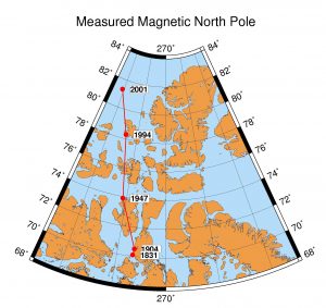
Earth's magnetic north pole is where the magnetic field lines are oriented vertically and plunge into the surface of the Earth i.e. where the magnetic inclination is +90 degrees. This is called the magnetic dip pole. The pole varies in position on a yearly basis due to secular variation (or drift in Earth's magnetic field). The British polar explorer Sir James Clark Ross measured the first location of the magnetic north pole on May 31, 1831 (70°5.3'N 96°46.0'W). The now famous Roald Amundsen made the second observation of the north magnetic dip pole in 1904 (70°31'N 96°34'W) during his voyage through the northwest passage. Canadian government scientists have since measured the location of the magnetic north pole beginning in 1947 and continuing through 1994 and 2001. Below is a map showing the 1831 location measured by Ross and the subsequent 1904, 1947, 1994 and 2001 locations. The magnetic north pole has progressively moved offshore over the past few years. The geophysical significance of the measured Magnetic North Pole (dip pole) location is actually only of marginal scientific interest or importance, the primary interest has more to do with public outreach. A more important estimate of the magnetic north pole comes from the reference field model of the geomagnetic field, the International Geomagnetic Reference Field (IGRF).
The following table is from the Canadian government estimates of where the North Magnetic Pole (dip pole) is moving over the next few years. The observed position is shown for 2001 followed by predicted locations. A recent estimate of the pole location for April 2007 was published by Newitt et al. [2009] using measurements made on the ice.
| Year | Latitude ( °N) | Longitude ( °W) |
|---|---|---|
| 2001 | 81.3 | 110.8 |
| 2002 | 81.6 | 111.6 |
| 2003 | 82.0 | 112.4 |
| 2004 | 82.3 | 113.4 |
| 2005 | 82.7 | 114.4 |
| 2007.3 | 83.95 | 120.72 |
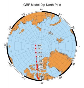
As noted above a more geophysically important estimate of the magnetic north or south pole is based on the global magnetic field models (i.e. the International Geomagnetic Reference Field (IGRF) models). This global field model based on satellite and geomagnetic observatory data is a spherical harmonic expansion of what are called Gauss coefficients named for Carl Friedrich Gauss who was a german mathematician who devised this approach to model the geomagnetic field in 1831. These computed IGRF model pole positions are generally quite different than the actual measured dip pole and careful attention to the assumptions are needed for each calculation. For example, we can compute the Geocentric Axial Dipole north pole using the best-fitting dipole model of Earth's magnetic field, which uses the first three terms (i.e. dipole terms; degree-1) of the spherical harmonic model. This is often called the Centered Dipole (CD) model. The CD northpole is located in northern Greenland. We can compute the best-fitting Eccentric Dipole (ED) north pole, which incorporates the first 8 terms of the spherical harmonic model (i.e. up to degree-2). Alternatively, we can use all 120 of the terms of the spherical harmonic model (up to degree-10) and compute the IGRF Model Dip pole. Below is a figure of the magnetic north pole location based on the computed IGRF Model Dip from 1900 to January 1st 2015 (2020 location is predicted). This is called the IGRF Model Dip Magnetic North Pole.
To get more information on the latest location of the Magnetic North Pole check out the following web sites.