

THE U.S. OREGON AND WASHINGTON STATES, AND THE CANADIAN PROVINCE OF BRITISH COLUMBIA FORM PART OF THE GEOLOGICALLY ACTIVE CONTINENTAL MARGIN OF NORTH AMERICA. This region—often referred to as central-northern Cascadia or the Pacific Northwest (PNW)—includes large-scale tectonic and volcanic features that represent major geohazards for the local populations and built environment of this region including the subducting Gorda/Juan de Fuca/Explorer oceanic plate system (JdF), the Cascadia accretionary margin and forearc, and the Cascade Volcanos.Read more
At the Cascadia Subduction Zone, the ongoing descent of the JdF plates beneath the northwestern coast of North America has generated large earthquakes and associated tsunamis in the past. The last great earthquake at Cascadia occurred on January 26, 1700 AD and is estimated to have been a magnitude 9, similar to the devastating 2011 earthquake in Japan. Studies of the older history of earthquakes along the margin indicate they occur every 300 to 550 years at Cascadia and scientists estimate an ~14% chance that the next great earthquake will happen in the coming 50 years. The subduction zone at present is eerily quiet with little seismicity detected within the Oregon to Washington portion. Scientists believe this lack of seismicity reflects the “locked” state of the megathrust at present and that stresses are currently quietly accumulating as the JdF plate system steadily descends beneath North America. With the paucity of recorded seismicity little is known of the properties of the subduction zone fault interface (i.e., depth, roughness, thickness, and acoustic impedance, among others) within the mega-thrust earthquake zone and how they vary along and across the Oregon to British Columbia margin. The current observations allow for a wide range of possible future earthquake and tsunami scenarios. Comprehensive characterization of this zone is needed to quantify earthquake and tsunami hazards within the region.
Scientists from a number of U.S. and Canadian academic and federal institutions are proposing to conduct geophysical investigations that will provide the observations and data necessary to address fundamental science questions relevant for understanding the structures and processes that contribute to, and result from, earthquakes, tsunami, and associated geohazards in the PNW. Because the geological targets are located offshore, the proposed projects include deployment of ocean-bottom instrumentation that will record natural seismicity and seismic waves from marine acoustic pulses, and marine seismic reflection imaging techniques. The proposed data collection will make use of the U.S. National Seismic Research Facility R/V Marcus G. Langseth, the U.S. academic research vessel Oceanus, and ocean bottom seismic instrumentation from academic as well as commercial providers.

Proposed Projects


Principal Investigators
- Suzanne Carbotte, LDEO
- J. Pablo Canales, WHOI
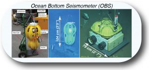 We call OBSs to instruments that are generally larger in size (~1m by 1m by 1m), have sensors capable of responding to lower frequency sources, and operate in shallow to very deep ocean depths (up to ~6,000 m). OBS are generally deployed from ships as free-fall instruments which sink due to the weight of an anchor (
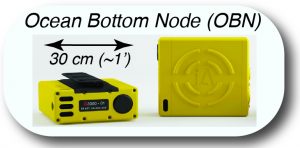 We call OBNs to instruments that are smaller in size (~1 foot by 1 foot ~ 6 inches), are sensitive to higher frequency sources, and operate in shallow to intermediate ocean depths (up to ~3,000 m). Due to their reduced size, OBNs lack buoyancy and therefore have to be deployed on, and retrieved from, the seafloor using remotely operated vehicles (ROV).